Florida’s Wetter Wild Ride: What Surprises Await in the Stormy Skies?
Florida, known for its sunny beaches, is currently bracing for a wave of intense weather that could disrupt daily life and outdoor plans. With forecasts predicting heavy rains and potential severe storms, residents in Central Florida are on high alert, as meteorologists warn of significant rainfall accumulation and storm risks that could lead to flooding and travel hazards. This early summer pattern isn't just a passing shower—it's a major event that highlights the growing impacts of seasonal weather shifts in the Sunshine State.
Drawing from multiple weather reports, the situation kicked off with a Weather Alert Day declared for Thursday, where scattered thunderstorms are expected to cover 50-70% of the area. Strong storms could bring gusty winds up to 60 mph, heavy downpours with 1-3 inches of rain in short bursts, and even isolated hail. The Storm Prediction Center has issued a Marginal Risk for most of Central Florida, emphasizing the potential for sea breeze collisions to spark these storms along the I-4 corridor, shifting eastward toward the coast by evening. As one report from WKMG ClickOrlando notes, this setup is classic for early summer, with a stalled front over North Florida keeping moisture high and instability rampant.
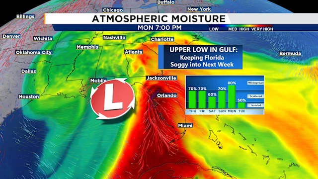
Comparing forecasts from sources like WESH 2 and FOX 35, the threats remain consistent: wind and hail as the primary concerns, with a lower but not negligible risk of tornadoes or localized flooding. Kellianne Klass from WESH highlighted the timeline, predicting impacts peaking between 3-8 p.m. on Thursday, right during the evening commute. This could turn routine drives into challenges, especially as storms linger into Friday and the Mother's Day weekend. FOX 35's analysis adds that highs will soar into the upper 80s, fueling more afternoon thunderstorms, with rain chances holding steady at 50-60% through the weekend. By early next week, a slow-moving upper-level low from the Gulf might push totals up to 7 inches in some areas, raising flood concerns—a stark reminder of how quickly weather can escalate from nuisance to danger.

Amid these developments, experts like Tony Mainolfi from WESH's First Warning Weather team urge preparation, pointing out that while Saturday might see scattered storms, Sunday could bring even heavier rain as a low-pressure system moves in. This not only affects holiday plans but also underscores broader environmental trends, such as increased moisture from climate patterns. The repeated emphasis on monitoring apps and radar reflects a proactive approach, blending real-time data with community alerts to mitigate risks.
In summary, Florida's rainy forecast serves as a critical wake-up call for residents to stay informed and prepared, potentially averting disruptions from severe weather. What do you think—will this storm system live up to the hype, or bring some unexpected twists? Share your thoughts in the comments below, and don't forget to spread the word to help others stay safe.