Is Florida Facing a Stormy Week Ahead?
Florida residents might want to keep their umbrellas handy as forecasts predict a week filled with heavy rains and potential storms. With weather patterns shifting dramatically, the state could see significant impacts on daily life, from travel disruptions to flooding risks. This emerging weather event highlights the unpredictable nature of Florida's climate, raising concerns for safety and preparedness across the region.
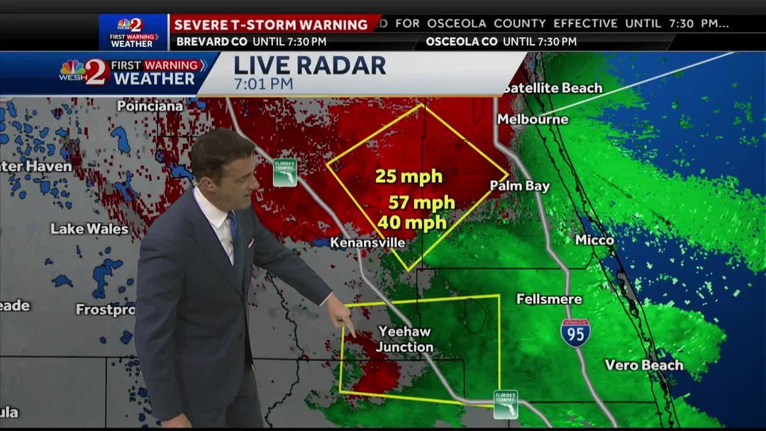
Drawing from recent reports, meteorologists are warning of scattered showers and strong storms starting as early as Wednesday. In Central Florida, areas like Orlando, Brevard, and Osceola counties are bracing for up to 7 inches of rainfall over the next seven days. WKMG ClickOrlando and WESH 2 forecasts indicate that afternoon storms could bring gusty winds up to 60 mph, frequent lightning, small hail, and heavy downpours, with some spots seeing 2-4 inches of rain in a single event.

Experts point out that an upper-level low over the Gulf is fueling this stormy setup, increasing rain chances to 40-70% daily through the weekend. Thursday appears to be the peak, with a Level 1/5 marginal risk for severe weather, including possible tornadoes. Comparisons to recent patterns show this could be more intense than typical seasonal storms, as a stalled front might prolong the rainfall, potentially easing drought conditions but heightening flood risks in eastern counties.
Meteorologists like Kassandra Crimi from WFTV have noted that isolated downpours could deliver over an inch of rain in a short time, with highs remaining in the mid-80s to low 90s. This creates a muggy environment that amplifies storm severity. For instance, WESH 2 has issued severe thunderstorm warnings for parts of Brevard and Osceola counties, emphasizing threats like quarter-size hail and strong winds. Such events underscore the need for vigilance, as highlighted by Chief Meteorologist Tom Terry, who urges residents to stay updated via apps and local alerts.

As the week progresses, scattered storms are expected to continue into early next week, with a potential washout over the weekend. This ongoing pattern not only disrupts outdoor activities but also provides much-needed relief for drought-affected areas. Analysts compare this to previous years' events, noting that while beneficial for water levels, excessive rain could lead to urban flooding and power outages.
In summary, this weather event serves as a reminder of Florida's vulnerability to extreme conditions. What might this mean for local communities, and how can residents best prepare? Share your thoughts in the comments below and stay informed by following reliable sources for the latest updates.