Is Florida’s Weather Whiplash Setting the Stage for a Turbulent Hurricane Season?
As Mother's Day celebrations unfold across Central Florida, residents are bracing for disruptive storms that could disrupt outdoor plans and hint at larger atmospheric shifts. This weather instability isn't just a fleeting inconvenience; it may foreshadow challenges in the upcoming hurricane season, raising questions about how regional patterns could amplify risks for millions.
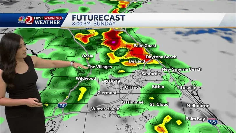
Central Florida is currently under a spell of unsettled weather, characterized by heavy rainfall, thunderstorms, and potential severe conditions. Meteorologists from WKMG ClickOrlando and WESH 2 have issued alerts for Impact Weather, particularly from 4 p.m. to 10 p.m. on Mother's Day, driven by a low-pressure system in the northern Gulf. This setup is pumping moisture into the region, leading to scattered storms with threats of hail, damaging winds up to 60 mph, and localized flooding. As David Nazario, a meteorologist at WKMG, explains in his analysis, "We're shifting gears dramatically once again from a very wet and rainy pattern to drying out," highlighting the rapid weather whiplash that's become a hallmark of 2025.

This isn't isolated to the holiday. Forecasts indicate widespread rain persisting into Monday, with a slight rise in tornado risks as a cold front moves through. The convergence of these factors ties into broader atmospheric oscillations, such as the Pacific North American Oscillation (PNA) and North Atlantic Oscillation (NAO). A negative PNA configuration, as Nazario notes, often brings drier conditions and stronger ridging, which could extend the Bermuda-Azores high pressure system. This might steer tropical systems westward, potentially directing hurricanes toward the Caribbean, Bahamas, or even Florida's Gulf Coast. Last year, similar patterns influenced storms like Helene and Debbie, underscoring the real-world implications.
Comparatively, while April brought drought and fire risks due to high pressure, May's flip to wetter conditions adds complexity. Experts caution that if this ridging persists, it could exacerbate hurricane threats during peak months like August and September. The rapid temperature swings— from mid-80s with storms to potentially record 90s by week's end— exemplify the volatility, making preparedness crucial for Floridians.
In synthesizing these reports, the key takeaway is the interplay between short-term disruptions and long-term risks. As temperatures climb and dry spells return mid-week, the stage may be set for a more active hurricane season, where even minor systems could escalate into major threats.
Ultimately, this weather narrative serves as a reminder of Florida's vulnerability to climate dynamics. What does this mean for your summer plans? Stay tuned and prepared. We encourage readers to share their experiences with these shifting patterns in the comments below and spread the word to help others stay informed.